
The National Weather Service issued a flood watch alert Friday for areas north of Allegheny County as rain and warm temperatures cause river ice to break apart and jam the region’s waterways.
The alert is in effect until 9 a.m. Saturday portions of northwest and Western Pennsylvania, including Armstrong, Butler, Clarion, Jefferson and Venango counties.
“As a reminder, ice jam flooding can come with little warning. Make sure to stay vigilant of conditions near rivers/creeks and never drive through flooded roadways,” the NWS said via their website Thursday. “Ice jams may result in flooding of rivers, creeks, streams, and other low-lying and flood prone locations.”
An earlier flash flood warning for southern Venango, northwestern Armstrong, northeastern Butler and Western Clarion counties expired at 4 p.m. Friday, according to the NWS.
Emlenton Fire Department issued a warning that a “potentially dangerous” ice jam had formed on the Allegheny River, and that residents should listen for a “prolonged blast” from the town’s fire siren in case of the need for immediate evacuation.
At 1:08 p.m. the Emlenton Fire Department reported that water levels were beginning to rise on parts of River Avenue.
“We are asking that onlookers please avoid the River Ave area as extra traffic will impede residents’ ability to leave quickly,” the department’s post said.
Other hazardous locations included anyone adjacent to the Allegheny River, Honeysuckle Road, some camps and houses along North Riverview Drive, according to the fire department.
On Thursday, the NWS issued a flood watch for areas where river ice breakup is “most likely” to occur, including Connoquenessing Creek, Oil Creek, Redbank Creek and the Allegheny and Yough rivers.
As of 2:45 p.m. Friday, NWS Meteorologist Mike Kennedy said there was no flooding in Allegheny County.
Kennedy said there was an advisory in place at Point State Park for water levels reaching 18 feet around 1 a.m. Saturday morning.
“That’s when water begins to flow into the Mon Parking Wharf,” he said.
However, the Fountain Plaza doesn’t flood until water levels reach 22.5 feet.
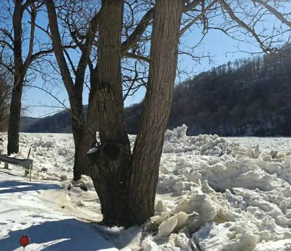
NWS Senior Service Hydrologist Alicia Miller, shared photos of the ice jam in Oil City.
Our Senior Service Hydrologist, Alicia Miller, shared these photos of the ice jam in Oil City. Some ice chunks measured 7.5" thick and, when piled up, can block river flow and potentially cause flooding.
Reminder: DO NOT WALK ON THE RIVER ICE! These could release w/o warning. pic.twitter.com/iw7QEqnTkv
— NWS Pittsburgh (@NWSPittsburgh) February 19, 2026
“Some ice chunks measured 7.5” thick and, when piled up, can block river flow and potentially cause flooding,” the post said.
Oil City Firefighters IAFF Local #700 also posted on social media Thursday that several downtown businesses had experienced flooding.