
Karen Wolfe did something this week that few others have done over the past 80 years.
She walked the main street of Somerfield and its 206-year-old Great Crossings Bridge, landmarks that are normally about 50 feet underwater at Youghiogheny River Lake in southwestern Somerset County.
“We had to come up and see this,” said Wolfe, who traveled with her family to the lake from her New Stanton-area home. “This is amazing. It’s probably 15 years that we’ve been coming up here boating, and we’ve never seen it like this.”
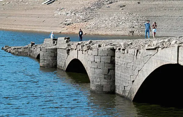
The bridge, an 1818 structure of cut sandstone, once carried Route 40 over the Yough River between Somerset and Fayette counties. Just upstream from the modern version of the highway and its much higher bridge, the Great Crossings span periodically emerges from the depths when dry weather causes low water levels in the man-made lake.
Bright skies and balmy temperatures in the 70s on Thursday afternoon brought a steady stream of visitors to the lake’s Somerfield Recreation Area, on the Somerset County side of the lake. They strolled on the portion of the historic bridge that juts out into the body of water, some preserving their experience with photos and videos.
Jack Kemp and his wife, Gail, drove east from their home in Hopwood, on the outskirts of Uniontown, to explore the bridge.
“It used to be you just saw the top part of it,” he said. “Now you can see it all.
“We’ve never walked down here before. We’ve just seen it going across the (modern) bridge. I’ve never seen the water this low.”
“Drought conditions are the reason,” said Andrew Byrne, public affairs specialist for the Army Corps of Engineers.
The Army Corps oversees the 6-mile-long lake and the dam near Confluence that created it in 1943 as part of a federal flood control program.
Rainfall has been sparse in the region, with much of Somerset, Fayette and Westmoreland counties subject to “severe drought” conditions, according to the National Integrated Drought Information System.
To the west, Connellsville is about 3 inches shy of the normal rainfall total for the year to date, while Pittsburgh is more than 2 inches below normal for September through late October, according to Shannon Hefferan, a meteorologist with the National Weather Service’s Pittsburgh office.
The Yough lake’s normal summer water elevation is 1,439 feet above sea level. The level was at 1,378 feet on Oct. 18 and had dropped by an additional 4 feet as of Friday.
The very top of the bridge becomes visible when the lake level is at 1,392 feet, and the bridge deck becomes exposed at 1,384 feet, according to Byrne.
The Yough dam construction inundated the Great Crossings Bridge, the Somerset County town of Somerfield and other small communities in either of the two affected counties.
Wolfe was able to recognize under a layer of dried mud the foundation blocks of a few Somerfield buildings, bordered by the remnants of a paved sidewalk dotted with decayed stumps.
“I saw an old picture of this,” she said of the town’s main drag. “There were buildings all along this sidewalk.
“This was a tree-lined street. This is so cool.”
Beyond the town’s resurfaced remains, Wolfe pointed out more modern landmarks that have taken on a new aspect: a Somerset County boat launch and Fayette County boat docks, all left high and dry.
Compared with other Somerfield structures, the Great Crossings Bridge impressed visitors with how intact it has remained.
“With the buildings, mostly they demo’ed everything. But they didn’t demo the bridge,” visitor Warren Keen said. “They could have demo’ed the bridge and reused the stone somewhere else, but they didn’t.”
Keen is a history buff with a particular interest in Route 40, the first federally funded U.S. road, built between 1811 and 1834. It is also known as the National Pike.
He made the three-hour trip from his home east of Frederick, Md., to view the Great Crossings Bridge on Monday.
When he returned Thursday, he said, “It’s kind of neat how it pops up. The water’s gone down just a little bit more.
“I love stone arch bridges.”
Scottdale resident Ryan Brooks recalled boating with neighbors on the Yough Lake when he was growing up, but his visit this week marked the first time he’d seen the exposed Great Crossings Bridge in person.
“I have friends in the area who said I should check it out,” he said. “I don’t know if it’s a once-in-a-lifetime thing, but it’s a once-in-a-while thing.
“They don’t build them like that anymore,” he said. “That’s beautiful with the old cut stone.”
“How things can hold up underwater like that, it’s just crazy,” Jack Kemp said.
Mel Houseman, who lives downstream along the Yough River in the Westmoreland County community of Jacobs Creek, took a road trip on his motorcycle to see the exposed bridge. He commented on both the positive and negative effects of the low water level.
There’s less chance that the river could flood and damage his home, he said, noting, “Where I’m at, the water’s real low, maybe knee-deep.”
But Houseman also recognized the economic hit to area businesses resulting from the depleted water and recreational opportunities at the lake.
“It’s got to be devastating to these people,” he said. “You’ve got the (boat) docks just lying on the bank. It takes a toll.”
Among those affected by the dry conditions are Tom and Carol Trent, who split their time between their Greensburg home and the Great Crossings Inn they own overlooking the Somerset County boat launch.
For the first time this year, they offered several Airbnb units, sought by tourists as well as those visiting local relatives. But the drought caused them to close operations earlier than they’d planned.
“We shut it down on Labor Day weekend, where we weren’t going to shut it down until probably this weekend,” Carol Trent said Thursday. “Everybody’s water wells were drying up, and we were concerned we were going to have an issue with water.”
“Financially, it definitely hurt not to have the inn open,” Tom Trent said. “But (we) couldn’t risk having to drill a new well.”
The low lake level allowed the couple to have the unusual experience of kayaking under one of the Great Crossing Bridge’s stone arches. But, as with many other lake visitors, it curtailed some of their other water-based activities.
The Trents normally pull their motor boat from the nearby lake marina in mid-September, but they did so a month earlier this year.
Compared with this season, the bridge wasn’t quite as exposed during low water levels the Trents observed in 2019, when they purchased the inn. But, they’ve seen family photos indicating the water level in 1998 was lower than it is now.
When the water level gets too low, Tom Trent noted, “You can’t safely get your trailer in deep enough to get your boat out.
“The whole area ‘died’ a month sooner, which is very impactful for all the businesses.”
“It definitely hurt the boating business,” Carol Trent said.
But, as boating activity on the lake decreased, the flood of sightseers coming to view the bridge increased. The lake’s changing level didn’t hinder those intent on fishing, who found new spots to try on the exposed bridge deck.
“It is a huge draw,” Tom Trent said. “Everybody comes to see it. On the weekends, there are almost as many people as during the summer, in boating season.”
Said Carol: “We should have sold T-shirts.”